Brother Steve met us early and we were on the road by 8:00 am. Heading south from Fayetteville we took a road that I had previously scouted in my truck some months earlier. I had found references to many spots marking the general direction for this part of our day’s journey. We stayed the night very near Cato Springs, which the Butterfield had passed through, and from there picked up Highway 245 and entered a long valley. Ormsby described his passage through here. “Even among these hills you do not lose sight of the prairie nature of the West; for just leaving Fayetteville, you see a fine plain surrounded with hills – in fact a prairie in the mountains.” It was a perfect morning for a ride and Highway 245 was a pleasant uncrowded two lane. Steve took some photos of the early morning adventurers. The next notable stop is at Hogeye, Arkansas. Not a scheduled stop on the timetable but somewhat notorious. Ormsby notably makes no mention of Hogeye. Other authors however, are quick to point out that at Hogeye there was an unscheduled stop which offered distilled corn whiskey in earthenware jugs. To understand the significance of this one might want to refer to some eyewitness accounts, including Ormsby’s, regarding the condition of the road as it left here and into the Boston Mountains.
The New York reporter wrote, "I might say the road was a steep, rugged, jagged, rough and mountainous and then wish for more impressive words."
The Postmaster General's Report(1858): "It is impossible that any road could be worse."
Hiram Rumfield, who was himself an employee of the Overland Mail Company, wrote to his wife in Ohio:"No one who has never passed over this road can form any idea of its bold and rugged aspect. It winds along the mountainside over a surface covered with masses of broken rock, and frequently runs in fearful proximity to precipitous ravines of unknown depth. Over such a route as this the coaches of the mail company are driven with fearful rapidity... The stage reels from side to side like a storm-tossed bark, and the dim of the heavily ironed wheels in constant contact with the flinty rock, is truly appalling. The man who passes over this route a passenger in one of the Overland Mail coaches without experiencing feelings of mingled terror and astonishment must certainly be oblivious to every consideration of personal safety."
It is perhaps a measure of Waterman Ormsby’s degree of professionalism and tact that he chose to leave out such an indelicate detail as the need to fortify oneself with mountain moonshine. Either that or, since this was the very first run, the old widow woman that was said to serve the draught had not yet measured the value of such libations to the, as yet, unsuspecting passengers. For you see, it was not until just beyond the Hogeye stop that the road turned to nightmare.
Paul and I found Hogeye without distinction but just beyond at a cross roads near the Illinois River was a most remarkable house from the time period of interest. It seemed abandoned but across the way was a convenience store so I went in to inquire. The locals were most helpful and it was here that I engaged an epiphany of sorts about the nature of our quest.
I am not really very comfortable with talking to strangers. Further, there is some weakness about me that engages a kind of terrified ineptitude when I go into these small out of the way rural stops. I open my mouth to speak plainly, but often find myself relying on long sentences and arcane phrases that degenerate into a kind of inane mumbling. Worse I even find myself affecting some poor approximation to the dialect and cadence of the folks I am talking to. This is usually and understandably disastrous. Their sharp eye and no nonsense practicality size me up in a moment and I am doomed to a justified appraisal as a lunatic or worse, a blow hard.
When I walked into this store there were several men standing about and their hard glances put me immediately into a defensive reticence. But this time instead of blustering I made a simple statement of my interests and asked about the old house and then explained our quest to find the Butterfield Stations and asked if they were familiar with the old stage line. What I noticed here and many times after, was a softening and even a genuine glow at the thought of the Butterfield. You could actually see them look away into their inner vision and down that long road that connected their sense of place with a sense of unfolding history. I wasn’t just asking directions to the next town, I was asking about their home and their roots and with genuine interest acknowledging the value of where they lived. It is actually with some emotion that I remember this very moment when the image of rough unforgiving men in out of the way places was replaced by kindness and encouragement behind those very same faces. This reaction, based on our shared mutual interest, was nearly universal, especially in the small nearly forgotten places along the way.
When I asked them about the house and wondered if it could be the Park’s Station they smiled and shook their heads. No, they were sure it wasn’t the Park’s Station, because it was located several miles further south. I was instructed that it was the first house north of the new shiny bridge and it will be on the west side just before you go down a long hill. The station is no longer there but the place is owned by Mr. Philpot. As for the old structure across the highway, well it is still occupied (amazing) and had once been located closer to the creek but since it kept getting flooded they moved the whole thing to higher ground. I thanked them and left.
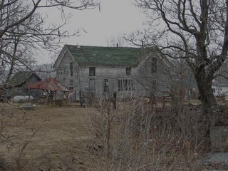
Looking at the rickety two story structure it seemed quite remarkable that it had been moved. Assured that it was not the Park’s station I didn’t see any reason to bother further to investigate. However, knowing now where the Park’s station was I feel that this old structure may very well have been the unscheduled stop at Hogeye. The coordinates are N35° 55.173' 94° 16.154'. I went back and got these pictures later.
To really appreciate the front porch you have to count the easy chairs.  There are five…… and at least two televisons.
We traveled further down the road and after passing Mr. Philpot’s we turned around and came backup the hill. Steve who had been following us in his truck went back up and found a cemetery while we talked with Mr. Philpot. Here on the right by the old well.
Mr. Philipot was a most gracious man. He was quite aware of the historic significance of his farm. He had recently built a nice brick ranch house and informed us that around 1995 a young couple had approached him and offered to tear down the dilapidated house in exchange for the old logs that were concealed beneath the exterior. The ancient logs could be sold individually and were a valuable incentive. Mr. Philpot felt the old house was really beyond restoration and consented. He burnt what remained of the structure but gladly showed us the flat area on which it stood and the remaining out buildings and old well.
Then he went into his house and returned with a wonderful photo of the building taken from the air. The station is to the right.  Park’s Station is at N35° 53.988' W94° 17.526' and overlooks the Illinois river valley below.
Below is the actual site on the day we visited. Mr. Philpot said that Mr. Park (John A. Park I believe) is buried in a small cemetery just north of his place and on the west side of the highway.
I asked Mr. Philpot about the old house we had seen at the highway junction near Hogeye. He didn’t know much about its history but noted with a smile that the old folks that lived there now were named Park.
It seems such a shame to have lost this beautiful historic structure so recently.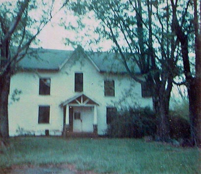
By most accounts the Stage usually ran with four horses. The exception seems to be at Tipton, where Ormsby noted a team of six horses “all harnessed and hitched.” At Park’s Station however, the team of four horses was traded for a set of sturdy mules.
“The wiry, light, little animals tugged and pulled as if they would tear themselves to pieces, and our heavy wagon bounded along the crags as if it would be shaken in pieces every minute and ourselves disemboweled on the spot. For fifteen miles the road winds among these mountains at nearly two thousand feet above the Gulf of Mexico. If Mr. Crocker (a superintendent of the line that Ormsby had met at Callahan’s) had not provided a most extraordinary team I doubt that we could have been able to cross in less than two days.”
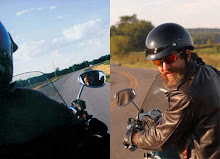
Here we are on our version of "wiry, light, little animals."
The next stop was the Strickland Station at Strickler. (7 miles, also known as Fall Creek)and was run by Benjamin Strickland and wife Mary Neuman.
In 1975 the Old log cabin with stone chimney still stood South of the Strickland Store. Hog-eye to Strickler was said to be the “Roughest10 miles between St. Louis and San Francisco. Mr. Philpot directed us to the old folks whose house now sits where the general store used to be. Said they could direct us to the ruins of the Strickland Station. We proceeded down the hill where we met Steve. The house was a low rambling structure close to the road. Five old cars were parked between it and the road. As I stepped off the bike I noticed a wheel chair ramp going between the cars and up to the door. Then I noticed the dog. He was a Chow mix and definitely on patrol. He had one of those, “Howdy, come over here and I’ll bite your ass” looks, so I got back on the bike and crossed the highway to Steve and Paul. I noted an overgrown lot opposite and slightly south of the house and wondered if perhaps that was the ruins. We did not get off the bikes to investigate but the location is at N35° 49.980' W94° 18.778'. I will go back and look again and maybe get past the Chow and talk to the “old folks.”
Highway 265 turns west here but the Butterfield went south on CR 216, otherwise known as “Bug Scuffle Road.” I had scouted this road on my previous trip. The Bug Scuffle Community was noted as being on the Butterfield run and though not an official stop it was an important link in my research in trying to determine how the line proceeded through the Boston Mountains. The Bug Scuffle Road follows along a ridge top and commands a magnificent view of the surrounding timber covered hills and eventually I was rewarded by finding the Bug Scuffle Community Church and Cemetery. N35° 47.555' W94° 20.366'.  The lone church looks to be rebuilt and stands as the only remaining structure of the hamlet of Bug Scuffle. The unusual name of the place arose when people gathered at this church (or waiting at the stage coach depot, depending on which version of the story you decide to believe), began wagering on athletic contests between tumblebugs fighting over a pellet of dung.
Just beyond Bug Scuffle the road turns steep and often rutted. Passage in my four-wheel drive truck was not really challenging. However, as we sat at the junction there was some discussion and we decided to bypass this section on our bikes in favor of exploring Devils Den State Park which listed a Butterfield hiking trail and I wanted to ask a few questions to make sure I was right in my assumption about the route.
The black top to Devil’s Den was a welcome interlude and the staff there were kind and assured me that their trail was related by name and proximity to the Butterfield but did not follow it. Steve left us at the park and it was also here that one of the Park Rangers made a copy of an article for me that was about a group of folks retracing the Butterfield trail for the Northwest Arkansas Regional Planning Commission in preparation for the Heritage Trail Project. The article was printed in the Ozarks Mountaineer August 2004 edition The intent is to combine the information about trails relating to the Butterfield, The Trail of Tears and the Civil War into a Community education program that includes pedestrian and bicycle paths associated with historical points of interest along the trail. Maps on their website later confirmed my own deductions about the trail in this part of the journey.
The funny thing about this side trip was that after discussing these things with the ranger we sought direction on getting back over to Highway 59. As a result we ended up taking a gravel road which followed Lee Creek and after about 8 miles of road that equaled or excelled Bug Scuffle in its intensity and daring it connected with Bug Scuffle Road right before the Lee Creek Crossing.
Velda Botherton, the author of the article in the Mountaineer believes the next stop, Brodie’s Station, was at Oliver’s Store on Lee Creek. She does not say where the store was but a magazine I found in a museum in Atoka, Oklahoma suggested the station was one mile south of the Lee Creek Crossing. We climbed out of the creek bed and connected to the new bridge that crosses Lee Creek as Highway 220 and road up the hill towards Cedarville. One mile from Lee Crossing puts you right at the junction of Old 12 Crossroads. It is not certain to me how closely the old trail followed Highway 220 but I found an interesting reference that ties these areas together.
At a web site called theshadowlands.net there is a list of haunted places in Arkansas. Under North of Cedarville, Arkansas:
At the top of the mountain at Dry Hill Rd. going south on Highway 220, off the to the right side of the road is part of the old Butterfield Stage Coach Rd. “Hunters have always reported the sound of someone whistling a strange tune. When they search the surrounding area to make sure it’s not a joke from someone it always stops when you step onto the old stage coach road. The whistling stops and u can hear a team of horses running as if the old stagecoach is making another run. “
On my previous run I had stopped there and explored and could find an old road off to the west but it was not convincing. On this trip however we did stop just opposite Dry Hill road. There is a house and a trailer there and we visited with a couple of guys burning trash in the front yard. “Oh yeah”, one of them said, when I asked them about the Butterfield road. “It ran right through here In fact that double-wide sits right on it.” As he spoke I could see the ghost of a road paralleling the highway headed south into the timber. So though it is still unclear exactly where Brodie’s Station was, it seems clear that it came this way from the Lee Creek Crossing and likely crossed Old 12 at the “Crossroads” and continued south underneath the double-wide towards Cedarville. The coordinates of the junction of Old 12 Crossroads are N35° 41.457' W94° 19.822'. Obviously, more research is needed here to pin down the exact location and on this and the next station but we were delighted to know we were on the right road. Steele says; “the old dog-trot log home at Brodie’s was moved to East Siloam Springs, Arkansas in 1983 and is being restored.
Woolsie’s Station presents even more challenges. Alternately referred to as Woolsies, Woosley's, Awsley’s, Oursley’s and Signal Hill it is sited by some authors to be as far away as a few miles west of Winslow and referred specifically to as the old C.C. Colllier /Yoes Farm and as the highest point in the Boston Mountains. None of these things have helped to locate the Station as yet. Velda Botherton, in the same article in the Mountaineer says she believes it to be in Cedarville.
One author,(Steele) shows a picture of a nice log structure and purports it to be the Signal Hill Station. Yet he says it is only a few miles west of Winslow. The City of Winslow is at least 11 miles from the trail as we know it and 20 miles from Brodie’s.
Click Here for a Woosley Update and the correct spelling and location.(2007)
On a previous trip I had visited with some folks in Cedarville. They assured me that the old stage road is said to head north “around the mountain”. Also, the old stage stop was “back up the hill.” “ Look for the Tyson chicken farm sign and the name Lenora White on Water Road. I think.” The guy at the convenience store in Cedarville said that the house is (which is stone and is built using some of the old station stones) right on the site of the old station. At that time I took at trip back down that road. It was hard to imagine it as the coach road when I saw it as it is in a narrow draw right next to a creek. He was excited though to tell me that the story when he was a kid, was that the old station ruins were there and they found a bag of “Old” mail 1800’s still in the ruins. Now there is a nice little stone house. No one was home when I went there but we could try again. It is about a mile and a half on gravel road back to the Chicken farm. Looking at the map it seems quite possible that the road followed Lucian Wood road into the town of Cedarville. There were many roads that had stage lines other than the Butterfield. Some confusion is natural as these lines criss-cross the state. I wonder also if Old 12 Crossroads may have been named as such because it was the crossroads of two major thoroughfares which could have easily carried different stage routes. We stayed on 220 to Highway 59 and went through Cedarville N35° 34.187' W94° 22.013' and down into Van Buren.
There is no question that the stage crossed the river at the town of Van Buren. There is a plaque on the square by this courthouse N35° 26.074' W94° 21.32' and descriptions of the crossing, which was difficult due to the exposed mud flats on the Fort Smith side, are numerous. One interesting note is that in 1858 Ormsby crossed on “a flat boat much resembling a raft.” Not much later this flat boat was propelled by a team of horses which operated a turnstile and pulley system from the Fort Smith side of the river. By 1860 this had been replaced by a ferry.
Paul and I made our way to the Old Fort across the river.
The Old Fort was quite interesting. There is a focus there on the military history of the fort of course and quite a bit of information on “The Hanging Judge” Judge Parker.  We didn’t pick up any new significant information on the Butterfield there but were reminded of one of the unique traits of the Butterfield route and the scope of its enterprise. By contract, the route proposed by Butterfield had to meet several qualifications as defined in the Post Master General’s specifications. Unfortunately, some of these conditions were determined after the contract was signed and it fell to Mr. Butterfield as to how to alter his plans to comply.
Butterfield and company actually submitted three separate bids for mail service. The one that was actually chosen proposed a “bifurcated” route which in the east began from St. Louis and Memphis and converged here at Fort Smith and hence to San Francisco via what was termed the “ox bow” route. The Butterfield Overland Mail from St. Louis is generally acknowledged as a most remarkable feat superbly completed. There is equal agreement that the route from Memphis to Fort Smith was not so praise worthy. In part this could be attributed to the fact that originally the mail was planned to be transported by water down the Mississippi and up the Arkansas to Little Rock and then Fort Smith. Shortly before the first run it was discovered however that the boats could not travel past Little Rock and Butterfield was force to sublease to a stage line that operated from Fort Smith to Des Arc on the White River. It was the sub-contractors that failed to perform. After notification Butterfield himself traveled this section of the line to observe what was needed for an efficient operation and to insure that the necessary stock and equipment were made available. Once the Butterfield company took over the complete superintendence of the line they had the mail arriving on schedule by January and all was in order and without complaint.
On the day that Ormsby, John Butterfield and Judge Wheeler his wife and two children arrived in Fort Smith N35° 23.222' W94° 25.826' at 2 a.m. however, the Memphis mail had arrived just fifteen minutes ahead of them. (The next run found the stage delayed some 37 hours waiting for the stage from Memphis.) The town was alive with activity and much ado was made in the celebration of the late night event.  An hour and twenty minutes was spent in merging the mails and when the stage made its way across the Arkansas River, Ormsby was the sole passenger accompanying the Mail Agent and driver. John Butterfield and Judge Wheeler, his wife and two children all had accompanied the mail since the train in St. Louis were left behind and for the first time in 468 miles and three days Waterman Ormsby got to stretch out with a blanket on the luxury of an empty seat. For the next 16 miles he slept his way into Indian Territory.
Paul and I climbed on to our trusty steeds and sought out the road to Skulleyville and the next station. It is a little puzzling why Ormsby writes that they “forded the Arkansas” There seems to be no reason to do this once one is in Fort Smith. Perhaps as they headed south and he was required to cross the Poteau River he was, from his slumbering bench, only aware they were crossing yet another river and made an erroneous assumption.
Fort Smith was literally at the edge of the Indian Territories. From here both Ormsby and ourselve would be traveling into the Choctaw Reservation and other Indian Nations beyond. What is most remarkable is the degree of organization and sophistication the Indians had already achieved in dealing with their white neighbors. Because Oklahoma was predominantly Indian controlled, every aspect of the Overland Mail through this part of the country had to be approved by the Tribal Government and their record keeping was astounding. The Walker Station was run by the then Governor of the territory, Tandy C. Walker who was actually the president of the senate of the general council of the Choctaw Nation and had assumed the duties of Governor in January of 1858. Every Station and stop were controlled by toll bridges and highly regulated. Walker Station in Skulleyville, N35° 15.143' W94° 35.468' was not apparent and there really wasn’t any place for it to be hiding so we kept on without a stop. I later learned that there should have been a Historic Marker there for the Agency House.
Our next stop was not on the Butterfield Trail. I wanted to revisit Spiro Mounds. The Mounds are considered one of the four most important prehistoric Indian sites east of the Rocky Mountains. Because of the great quantity of the materials recovered and the variety and vitality of its art forms, Spiro has been linked to the "Southern Cult," an association of mound sites built and utilized during the Mississippian Period.
Spiro was an important center of commerce. The Spiro chiefs controlled trade between the vast reaches of the plains and verdant southeast woodlands. The museum there has some remarkable reproductions and amazing artifacts that were recovered. There is really not a lot left to see of the mounds and culture but I just wanted to stop in and make an offering to the ancestors for a safe passage across their land.
Back on the highways we made our way south towards Trahern’s Station. We picked up the old road at Shady Point and went towards where we expected to find find Trahern’s. It was located about a mile and a quarter SE from Latham. Called the Council House, it was the residence of Judge James N. Trahern a prominent family among those of Choctaw descent. Born 1808 in Mississippi. The ruins of a well built hewn log house are pointed by residents as the Trahern place. There is no indicators to show where the station was but 1 ¼ miles SE of Latham is pretty exact. N35° 6.659'W94° 47.271' but there was no indication of where it may have been. These coordinates don’t relate to an established road and we felt close enough on this one though if there was still a log structure it would have been nice to get a picture. Maybe next time. There is supposed to be a Historic Marker here, too.
Onward southwest via gravel road which was spectacular. Here was a nice cross roads that gave us the much needed reassurance that we were on the right road.  This is at N35° 5.523' W94° 51.079' and can’t be far from Trahern’s. There is a discontinuous road that arcs from Calhoun to Latham and then to Dog Creek which may have been the actual route.
We passed many buildings from the period including this one and the next one which really reminded us of the stables at Fitzgerald’s
Holloway’s Station was next. We kept going down the gravel road seen above and passed between Red Oak Mountain and Red Oak Peak just after we hit Highway 82.
Holloway’s Station was located two miles(maybe 3) northeast of Red Oak. William Holloway was granted the privilege of constructing a turnpike road and establishing a tollgate near his residence at the “The Narrows” on the “public road in this Nation leading from Fort Smith, Arkansas to Fort Washita in the Chickasaw country.” This turnpike was through the Narrows on upper Brazil Creek and his residence was on the road some distance east of the gentle pass itself. The Brazil creek parallels this road for some distance. I had marked the station at N34° 58.457' W95° 3.140' based on the information above. In Atoka I found a postcard reference in the museum that said it was 7 miles northeast of Red Oak. This would not put it at the 20 miles listed in the notes of Bailey the special agent of the Post Office Department. that traveled on the first east bound stage. . Regardless we didn’t see any obvious structure as we crossed Brazil Creek.
Taking 270 out of Red Oak. We turned left to Panola about 8 miles and then to the outer road to Riddle’s Station near Wilburton.
Captain John Riddle was granted the privilege of constructing a bridge across the Fourche Maline near his place of residence and establishing a tollgate at that point on the road leading from Fort Smith to Boggy Depot. His residence was on the west side of the Fourche Maline a little overt two miles east of Wilburton. Just east of Lutie. The station was near the old cemetery on the side of the hill a few hundred yards west of the creek. It had a coal mine which provided blacksmith coal to several other stations. Proceed into Wilburton and follow railroad tracks SW towards Blue Mountain.
We found the cemetery N34° 55.132'W95° 15.595' near Lutie and could imagine the road across the creek in the pastures beyond but there was no sign of Riddle’s Station that we could find. Wished we would have taken a picture of the cemetery and I think I was looking for the station on the east side. It might be there and we were just looking in the wrong direction. I did find a reference that there is a Historic Plaque there.
The day grew late and it began to feel like a long way Fayetteville, Arkansas. We scouted a Best Western, bought some well deserved beers, put them with some ice into the sink of our motel room and settled in to our nightly routine of organizing and posting pictures for our families back home.
posted by Don and Paul Matt at 1:03 PM
1 comments
![]()
